Grasmere Circular Walk from Rydal (Coffin Trail Route)
The Grasmere walk is one of the most accessible and rewarding walks near Ambleside, combining lakeside paths, woodland trails and classic Lake District scenery.
This circular walk is generally easy going and offers excellent rewards for relatively little effort, although it is around twice the length of the Rydal Water walk. Including optional detours and time in Grasmere, allow around 3 to 4 hours, or closer to 5 hours if you plan to stop for refreshments, photography, or to explore the village.
Grasmere circular walk map (Route 2)
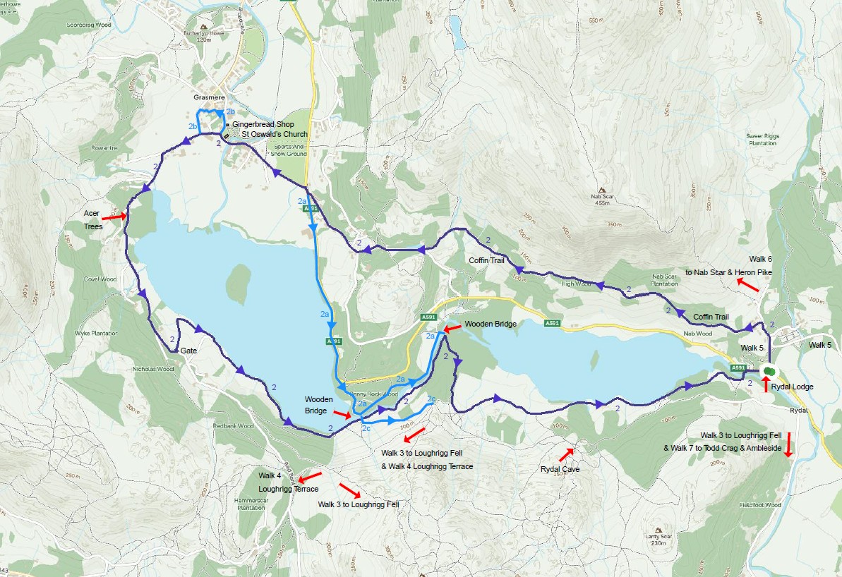
This map shows the main Grasmere circular walk route (Route 2), starting from Rydal village and following the Coffin Route. Alternative routes and variations are available via the downloadable map below.
Download Walk Map (PDF)Distance: 9.3 km (5.8 miles)
Difficulty: Moderate
Time: 2 hours 40 minuets
Total Ascent: 180 metres
Start point: Rydal village (alternative access from White Moss car park)
Highlights: Rydal Water walk, Coffin trail, Grasmere, Loughrigg Terrace route
Route description
Leave Rydal and walk up the road directly opposite Rydal Lodge. The climb is fairly steep as you pass St Mary’s Church and continue towards Rydal Mount, once home to William Wordsworth. Just beyond Rydal Mount, look for a track witha gate set slightly back on the left — this is the Coffin Trail, one of the Lake District’s most well-known walking routes.
The historic Coffin Trail
The path above Rydal Water is known as the Coffin Trail, an old funeral route used for centuries to carry the dead from Rydal and Ambleside to St Oswald’s Church in Grasmere.
At the time these villages had no consecrated burial ground, so coffins were carried along this hillside path to the churchyard for burial. Along the route there were traditionally “coffin rests” — flat stones where the bearers could set down the coffin to rest before continuing their journey across the fells.
The path is generally straight forward, with a few gates and minor obstacles along the way. It undulates gently and looselyfollows the road below. This section can be busy, with walkers travelling in both directions, and there are a couple of benches near the midpoint for a short rest.

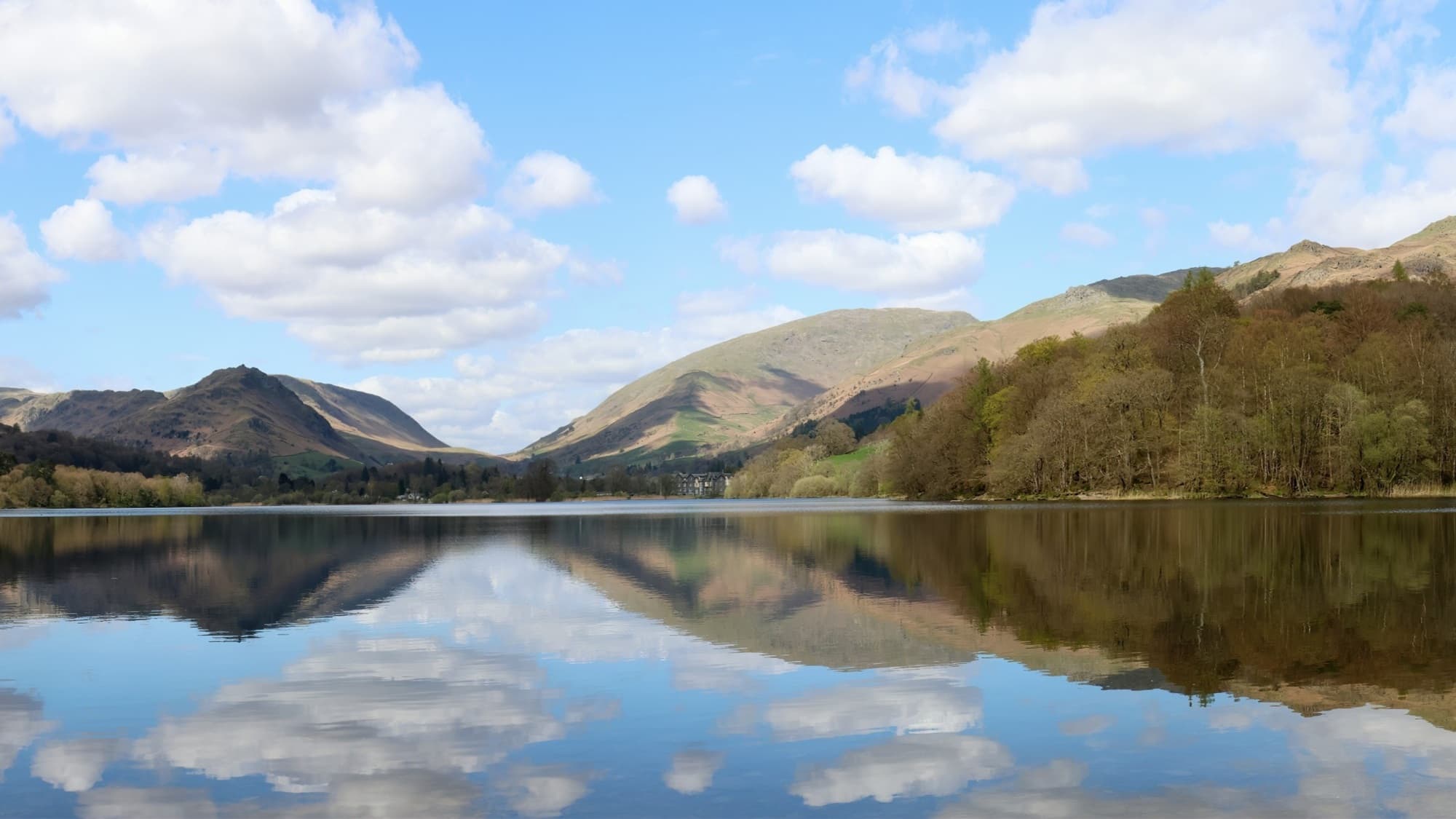
The islands on Rydal Water
Two small wooded islands sit near the centre of Rydal Water in the Lake District and are one of the lake’s most distinctive features. These tiny islands create the classic view seen from the Coffin Trail and from Nab Scar above the lake.
Their reflections in calm conditions make them a favourite subject for photographers walking around Rydal Water. The larger island is Heron Island, the smaller of the two is known as Little Isle. Walkers following the Coffin Trail or the path around Rydal Water enjoy some of the best views of the islands reflected in the lake
Arriving in Grasmere
As the path rejoins the main road near the roundabout, you’ll see the road leading into Grasmere village. A short detour brings you to St Oswald’s Church, where you can visit the graves of William Wordsworth, his family, and Robert Carlyle. The churchyard also offers a poignant glimpse into local history, with several graves marking the early loss of children to diseases such as tuberculosis.

Nearby is the famous Grasmere Gingerbread Shop, a popular stop for walkers exploring Grasmere village.

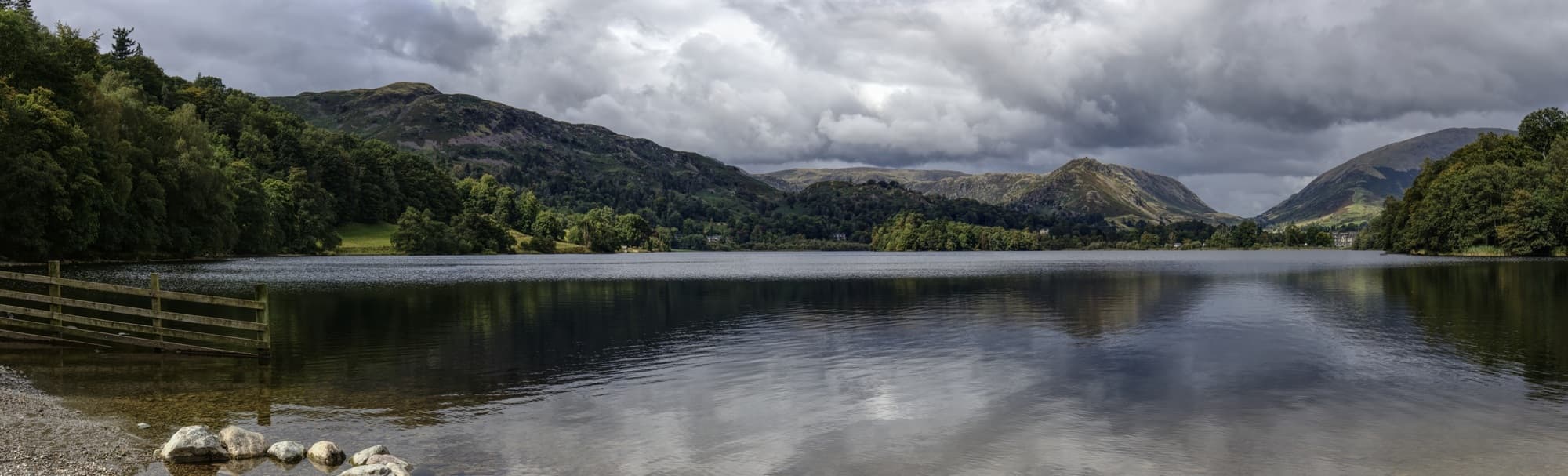
GrasmereWaterside Walk
From the village, there is a short stretch along the road before joining the path that skirts the far side of Grasmere (the lake). You’ll pass ornamental gardens and attractive cottages, including one with a traditional Royal Mail postbox set into the wall. Shortly after, a gated track on the left leads down to the water’s edge.
This section offers some of the best views of Grasmere village and the surrounding hills. On calm days, reflections across the water make for excellent photographs, while more dramatic weather can create equally striking scenes. At the far end of the lake, a small beach area is often busy with families, wild swimmers, paddleboarders, and canoeists, adding a lively contrast to the quieter sections of the walk.
The return takes you on the Southern shorelines of both Grasmere and Rydal Water. When you get to the point between Grasmere and Rydal Waters, you will also have the option of walking on a higher elevation above Rydal Water along Loughrigg Terrace, or a more energetic return via Loughrigg Fell.
Highlights of the Grasmere walk
- Historic Coffin Trail
- Views across Rydal Water of Rydal Cave & Loughrigg Fell
- Grasmere Village, Grasmere
- Classic Lake District fell terrain
Other walks near the Grasmere Walk
This route forms part of a collection of excellent walks around Ambleside and Rydal Water in the central Lake District, ranging from lakeshore paths to short fell climbs with panoramic views.
Loughrigg Terrace walk from Rydal Water – One of the Lake District’s most scenic paths, running high above Rydal Water and Grasmere.
Loughrigg Fell walk from Rydal Water – A rewarding short fell with panoramic summit views over Windermere, Elterwater, Rydal Water and Grasmere.
Rydal Water circular walk – A classic easy route around the lake, with lakeshore paths, woodland sections and views across Rydal Water and towards Windermere.
Parking at Rydal Water (Best Places to Park for Walks)
Several small car parks provide access to the Loughrigg Fell walk around Rydal Water.
White Moss Car Park – approximately 140 spaces located northwest of Rydal Water between Ambleside and Grasmere.
Pelter Bridge Car Park – around 15 spaces located south of Rydal Water near the bridge crossing the River Rothay.
Rydal Lodge (for guests) — Guests staying at Rydal Lodge can avoid parking altogether, with direct access from the garden onto a network of footpaths leading to Rydal Water, Loughrigg Terrace, Loughrigg Fell and beyond. It’s an ideal base for exploring the area on foot.
Where to stay near the Grasmere Walk
Many walkers choose to stay between Ambleside and Grasmere to enjoy direct access to routes like Rydal Water, Loughrigg Terrace and the Coffin Trail without needing to drive each day. Staying in this central area allows you to start walks from the door while still being within easy reach of both villages. Rydal Lodge sits in this position beside the River Rothay, with footpaths leading directly to Rydal Water and surrounding fells.
Stay at Rydal LodgeDownload Walk Map (PDF)