Loughrigg Terrace Walk from Rydal (with Rydal Cave Detour)
The Loughrigg Terrace walk from Rydal near Ambleside is one of the best easy walks in the central Lake District, combining gentle paths with some of the finest elevated views in the area.
Following the well-known terrace path above Rydal Water, the route offers a largely level walk with continuous lake views, woodland sections and the option to detour to the impressive Rydal Cave along the way.
It’s a relaxed, low-effort walk with exceptional scenery throughout, making it one of the most popular routes for walkers looking to experience classic Lake District landscapes without a demanding climb.
Loughrigg Terrace walk map (Route 4)
This map shows the Loughrigg Terrace walk (Route 14), starting from Rydal village and following the shoreline. Alternative routes are available via the downloadable map below.
Download Walk Map PDFDistance: 5 km (3.1 miles)
Difficulty: Easy
Time: 3-4hours
Total Ascent: 209 metres
Start point: Rydal Water near Ambleside, close to Rydal village and Rydal Lodge
Highlights: Grasmere, Rydal Water views & Rydal Cave
Route distance and ascent calculated using Ordnance Survey mapping.

Route description
This easy-going walk from Rydal follows the elevated path of Loughrigg Terrace, with the option to detour to the impressive Rydal Cave along the way. It’s one of the most rewarding low-effort walks in the area, offering lake views, woodland paths and classic Lakeland scenery.

Leave Rydal and follow the road west. Take the opening in the stone wall on the left and cross the wooden bridge over the River Rothay. Turn right and follow the path around the headland. As you pass through the wooded area, the path divides.
Lower Path - Offers stunning lakeside views of Rydal Water. When you pass the ruin on the right follow the rising path as it heads on towards Grasmere, and not through either of the gates on the right which head down to the river and Grasmere Beach.
Higher Path - leads to Rydal Cave. A worthwhile detour on the Loughrigg Terrace Walk, Rydal Cave is a large man-made cavern formed during slate mining over 200 years ago. Slate steppingstones lead into the cave, where still water on the floor often reveals small fish in the clear pool.

Both Higher & Lower paths provide striking views across Rydal Water towards Nab Scar and the surrounding fells.
When you pass the ruin on the right follow the rising path as it heads on towards Grasmere, and not through either of the gates on the right which head down to the river and Grasmere Beach.
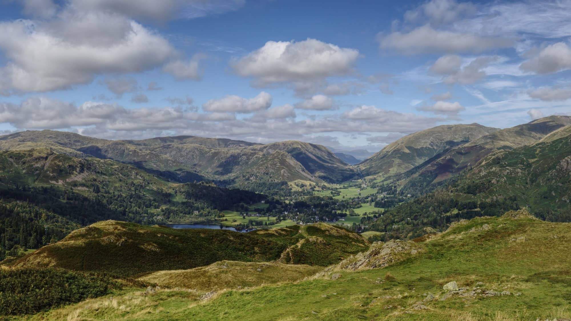
Continue along Loughrigg Terrace, where Grasmere Beach (hero image) soon comes into view. Numerous benches line the path, offering peaceful places to pause and enjoy the outlook. The path carries on past where the steep steps head off on the left up to Loughrigg Fell.
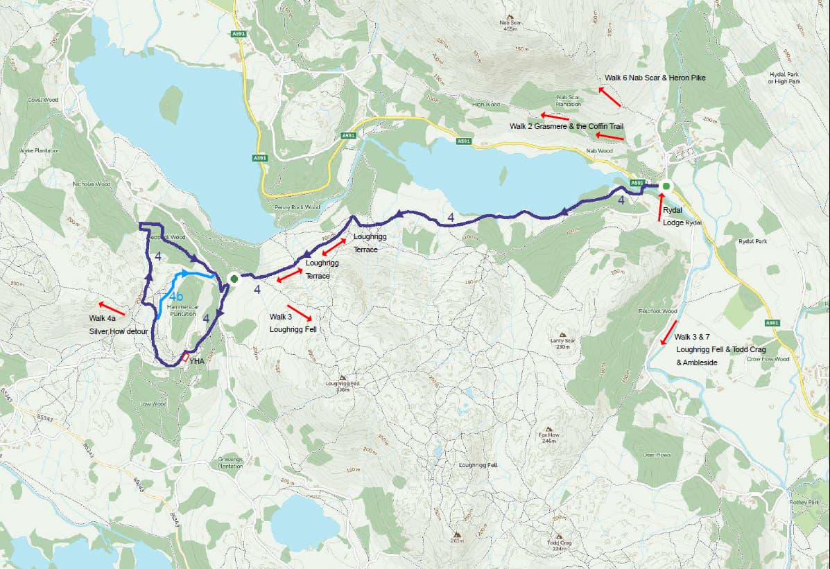
Optional ascent: Loughrigg Fell For those with a little more energy, the climb to Loughrigg Fell (above) is well worth the effort, as it provides impressive higher elevated views. Alfred Wainwright regarded Loughrigg Fell as offering one of the finest returns for effort among the Lakeland fells, with exceptional views gained from a relatively modest ascent.
If you prefer to keep the walk easy, continue along Loughrigg Terrace, where you will enjoy numerous stunning views of both Grasmere and Rydal Water.

The following two images were taken from the path heading up to Silver How and looking back to Rydal Water.
The following shows the dragonfly pond, with Windermere in the distant background.

From the path you will see a boggy stream with some stepping stones. Cross the stream and head off slightly left to a rocky climb. The stream opens out to a boggy patch which can be navigated then there is a pretty well-defined path leading away.
You will arrive at a rocky outcrop and hill after a boggy patch with stepping stones, where you should head right and follow the path that skirts the hill. You will see the summit of Silver How in front of you as you skirt around the hill. You need to do a short scramble around the back of the summit to arrive at the summit of Silver How.

From here you pretty much follow the ridge line back down to where you started from doing a complete circuit of the fell.
On your return, look out for the ruined farmhouse before descending towards Rydal Water. From here, you can follow the Southern shoreline back towards Rydal, or take the well-known Coffin Route, a historic path linking Rydal and Grasmere.
Highlights of the Loughrigg Terrace walk
- Panoramic summit views across Rydal Water, Grasmere and the central Lake District fells
- Rydal Cave
- Easily reached from Rydal Water
- Easily reached from Rydal
Other walks near Loughrigg Terrace
This route forms part of a collection of excellent walks around Ambleside and Rydal Water in the central Lake District, ranging from lakeshore paths to short fell climbs with panoramic views.
Loughrigg Fell walk from Rydal Water – A rewarding short fell with panoramic summit views over Windermere, Elterwater, Rydal Water and Grasmere.
Grasmere circular walk from Rydal — A rewarding circular route via the Coffin Trail to Grasmere, returning along the lakeshore. Offers a mix of woodland paths, open fell views and time in the village.
Rydal Water circular walk – A classic easy route around the lake, with lakeshore paths, woodland sections and views across Rydal Water and towards Windermere.
Parking near Loughrigg Terrace (Best Places to Park for Walks)
Several small car parks provide access to the Loughrigg Fell walk around Rydal Water.
White Moss Car Park – approximately 140 spaces located northwest of Rydal Water between Ambleside and Grasmere.
Pelter Bridge Car Park – around 15 spaces located south of Rydal Water near the bridge crossing the River Rothay.
Rydal Lodge (for guests) — Guests staying at Rydal Lodge can avoid parking altogether, with direct access from the garden onto a network of footpaths leading to Rydal Water, Loughrigg Terrace and beyond. It’s an ideal base for exploring the area on foot.
Where to stay near Loughrigg Terrace
Many walkers choose to stay between Ambleside and Grasmere to enjoy direct access to routes like Rydal Water, Loughrigg Terrace and the Coffin Trail without needing to drive each day.Staying in this central area allows you to start walks from the door while still being within easy reach of both villages.Rydal Lodge sits in this position beside the River Rothay, with footpaths leading directly to Rydal Water and surrounding fells.
Stay at Rydal LodgeDownload Walk Map PDF