Rydal Water Circular Walk (Rydal Cave & Coffin Trail Route)
The Rydal Water circular walk is one of the most accessible and rewarding walks near Ambleside, combining lakeside paths, woodland trails and classic Lake District scenery.
Following the shoreline around Rydal Water, the route offers the option to detour to Rydal Cave and includes sections of the historic Coffin Trail, with wide views across the water towards Nab Scar and Loughrigg Fell.
It’s an easy, low-effort walk with consistently beautiful surroundings, ideal for a relaxed half-day exploring one of the most popular areas of the central fells.
Rydal Water circular walk map (Route 1)

This map shows the main Rydal Water circular walk route (Route 1), starting from Rydal village and following the shoreline with an optional detour to Rydal Cave. Alternative routes and variations are available via the downloadable map below.
Download Walk Map (PDF)Distance: 4.5 km (2.8 miles)
Difficulty: Easy
Time: 1.5 -2 hrs hours
Total Ascent: 145 metres
Start point: Rydal village (alternative access from White Moss car park)
Highlights: Rydal Water, Coffin route, Rydal Cave as an option
Route distance and ascent calculated using Ordnance Survey mapping.

Route description
Leave a Rydal car park and head toward Grasmere. Pass through the gap in the stone wall and cross the single-track bridge over the River Rothay. Follow the path to your right. In 100 yards your view over Rydal Water will include the islands and Nab Scar to your right.

At the water's edge, Rydal Water's boat house can be seen through the trees beneath Nab Scar.

From here, you have two main options. Both provide striking views across Rydal Water towards Nab Scar and the surrounding fells. Head round Rydal Water on a lower path, around the Southern bank.

Or, take the Rydal Cave detour:
Rydal Cave detour
Follow the path up hill to the wooded area. On exiting the wooded area, take the higher path towards Rydal Cave. A worthwhile detour on the Rydal Water Walk, Rydal Cave is a large man-made cavern formed during slate mining over 200 years ago.
Slate steppingstones lead into the cave, where still water on the floor often reveals small fish in the clear pool. The entrance frames excellent views across the lake towards Nab Scar and the surrounding fells.

If you took the Rydal Cave detour. On exiting the cave take one of the paths back towards the water's edge away from Rydal and towards Grasmere.
Both options will bring you to a derelict building with a tree growing from within — a striking example of nature reclaiming the landscape. Follow the track down through woodland along a sometimes muddy path to the river.
Cross the timber bridge and turn right. Several tracks branch left and right, eventually leading you towards Rydal Water or White Moss carparks. Continue straight ahead to reach the main road. Cross the road and look for two paths on the opposite verge. Both climb gently and lead to the historic Coffin Trail.
Turn right on the Coffin Trail to return to Rydal. On the trail, on the opposite bank you will see Rydal Cave and Loughrigg Fell.

The islands on Rydal Water
Two small wooded islands sit near the centre of Rydal Water in the Lake District and are one of the lake’s most distinctive features. These tiny islands create the classic view seen from the Coffin Trail and from Nab Scar above the lake.
Their reflections in calm conditions make them a favourite subject for photographers walking around Rydal Water. The larger island is Heron Island, the smaller of the two is known as Little Isle. Walkers following the Coffin Trail or the path around Rydal Water enjoy some of the best views of the islands reflected in the lake
The historic Coffin Trail
The path above Rydal Water is known as the Coffin Trail, an old funeral route used for centuries to carry the dead from Rydal and Ambleside to St Oswald’s Church in Grasmere.
At the time these villages had no consecrated burial ground, so coffins were carried along this hillside path to the churchyard for burial. Along the route there were traditionally “coffin rests” — flat stones where the bearers could set down the coffin to rest before continuing their journey across the fells.
Before modern roads were built, this hillside path was also the main route between Ambleside and Grasmere, used not only for funerals but by travellers moving between the two villages
The end of the trail will pass behind Rydal Mount, the former home of William Wordsworth.
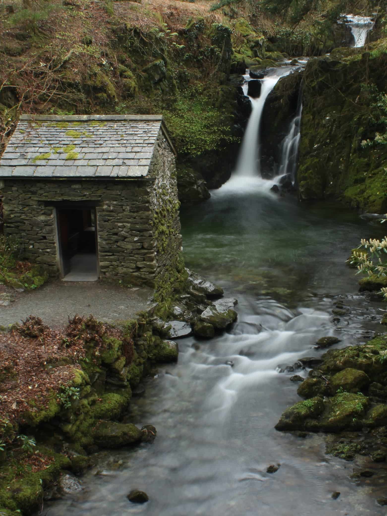
The building in front of you is Rydal Hall. The hall's gardens are open to the public. Sir Daniel Fleming developed the landscape and ‘The Grot' to incorporate Rydal Beck and its natural waterfall.
View from Nab Scar & Dora's Field
If you still have energy to burn, you might take the path leading up hill, which will reward you with magnificent views from Nab Scar over Rydal Water, Loughrigg Fell and Windermere. Or, you might take the road down into Rydal and turn right towards Grasmere. On your right you will find Dora's field, which was planted with daffodils as a memorial to William Wordsworth's daughter.


Highlights of the Rydal Water walk
- Classic Lake District fell terrain
- Rydal Cave easily reached from Rydal Water
- Historic Coffin Trail
- The Grot & Rydal Hall's gardens
- Panoramic summit views across Windermere, Grasmere and the central Lake District fells
Other walks near Rydal Water
This route forms part of a collection of excellent walks around Ambleside and Rydal Water in the central Lake District, ranging from lakeshore paths to short fell climbs with panoramic views.
Loughrigg Terrace walk from Rydal Water – One of the Lake District’s most scenic paths, running high above Rydal Water and Grasmere.
Loughrigg Fell walk from Rydal Water – A rewarding short fell with panoramic summit views over Windermere, Elterwater, Rydal Water and Grasmere.
Grasmere circular walk from Rydal — A rewarding circular route via the Coffin Trail to Grasmere, returning along the lakeshore. Offers a mix of woodland paths, open fell views and time in the village.
Parking at Rydal Water (Best Places to Park for Walks)
Several small car parks provide access to the Loughrigg Fell walk around Rydal Water.
White Moss Car Park – approximately 140 spaces located northwest of Rydal Water between Ambleside and Grasmere.
Pelter Bridge Car Park – around 15 spaces located south of Rydal Water near the bridge crossing the River Rothay.
Rydal Lodge (for guests) — Guests staying at Rydal Lodge can avoid parking altogether, with direct access from the garden onto a network of footpaths leading to Rydal Water, Loughrigg Terrace and beyond. It’s an ideal base for exploring the area on foot.
Where to stay near Rydal Water
Many walkers choose to stay between Ambleside and Grasmere to enjoy direct access to routes like Rydal Water, Loughrigg Terrace and the Coffin Trail without needing to drive each day.Staying in this central area allows you to start walks from the door while still being within easy reach of both villages.Rydal Lodge sits in this position beside the River Rothay, with footpaths leading directly to Rydal Water and surrounding fells.
Stay at Rydal LodgeDownload Walk Map (PDF)