Loughrigg Fell Circular Walk from Rydal Water
The Loughrigg Fell circular walk from Rydal Water near Ambleside is one of the best moderate walks in the central Lake District, combining steady climbing with some of the finest panoramic views in the area.
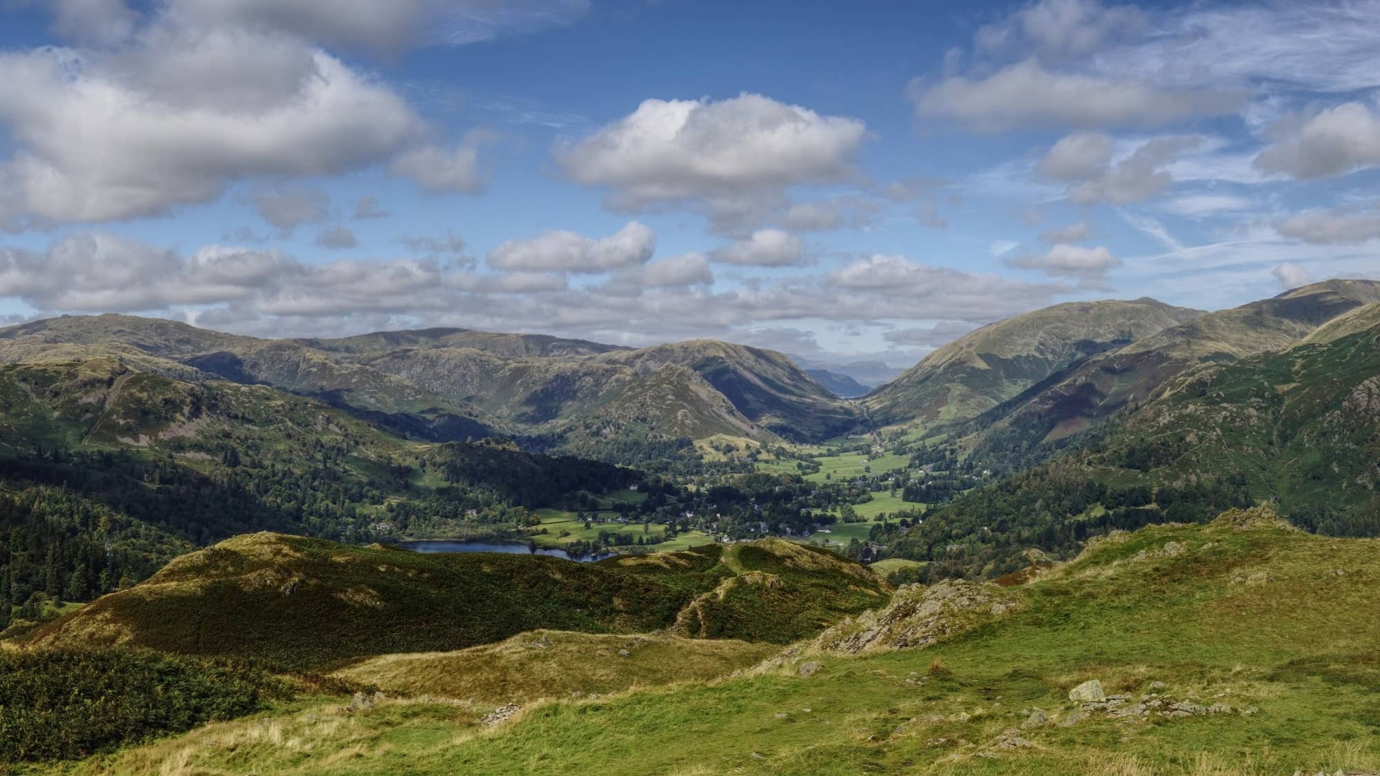
From the lower paths around Rydal Water, the route rises onto open fellside, passing Lily Tarn before reaching a series of summits with views across Windermere, Grasmere and the Langdale Pikes.
It’s a varied and rewarding half-day walk, offering a stronger sense of achievement than lower-level routes while remaining accessible to most regular walkers.
Loughrigg Fell circular walk map (Route 3)
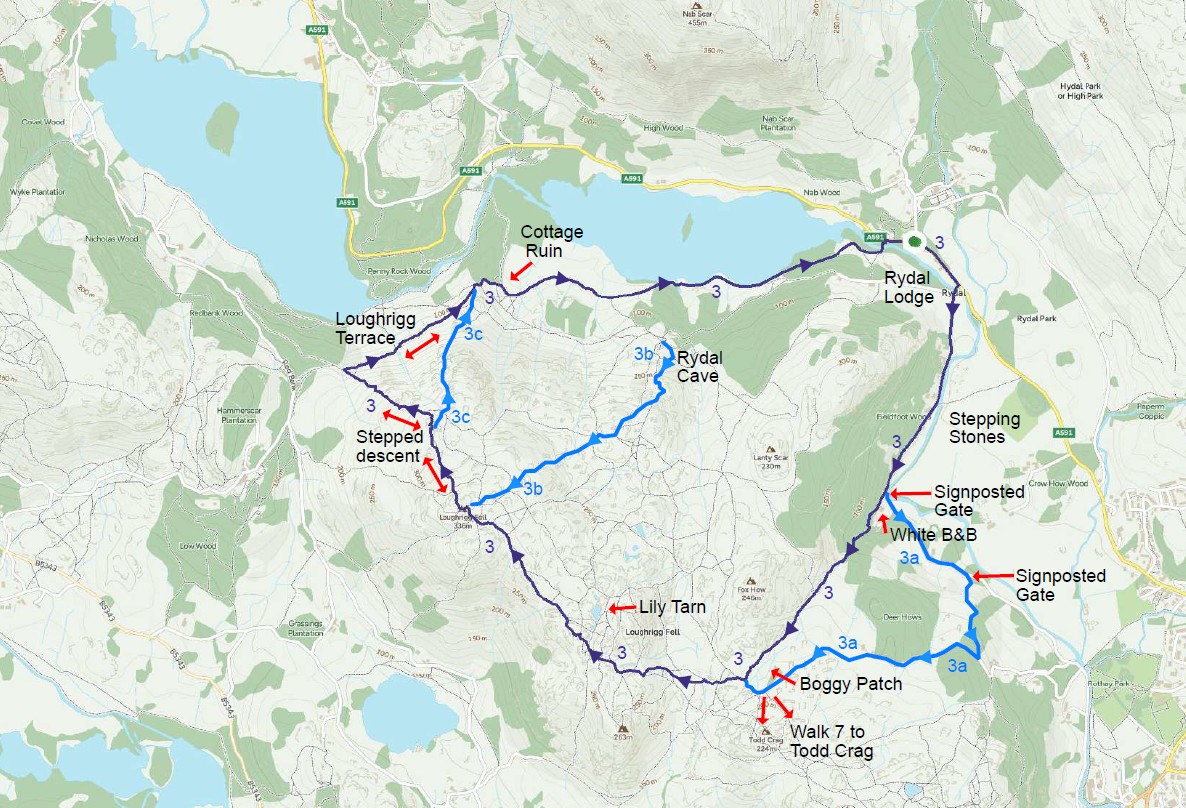
This map shows the main Loughrigg Fell circular walk route (Route 3), starting from Rydal village with an optional detour to Rydal Cave. Alternative routes and variations are available via the downloadable map below.
Download Walk Map PDFDistance: 7 km (4.3 miles)
Difficulty: Moderate
Time: 3–4 hours
Total Ascent: 336 metres
Start point: Rydal Water near Ambleside
Highlights: Summit panorama, Lily Tarn, Grasmere views, Rydal Cave
Route distance and ascent calculated using Ordnance Survey mapping.
Route description
Leave Rydal and head toward Ambleside, crossing the single-track bridge over the River Rothay. Continue beyond the cattle grid and follow the lane. Shortly after, the first steep ascent option appears before the white cottage.
The initial climb is strenuous for approximately half a mile, rising steadily with expanding views over Rydal Water and Fairfield Horseshoe.

The track runs alongside a stream and stone wall before reaching a boggy section.
From here, head toward the ridge, keepings lightly right if you wish to detour via Lily Tarn.

From here, head toward the ridge, keepings lightly right if you wish to detour via Lily Tarn. A network of paths leads to the trig point at 335 m — the true summit of Loughrigg Fell.

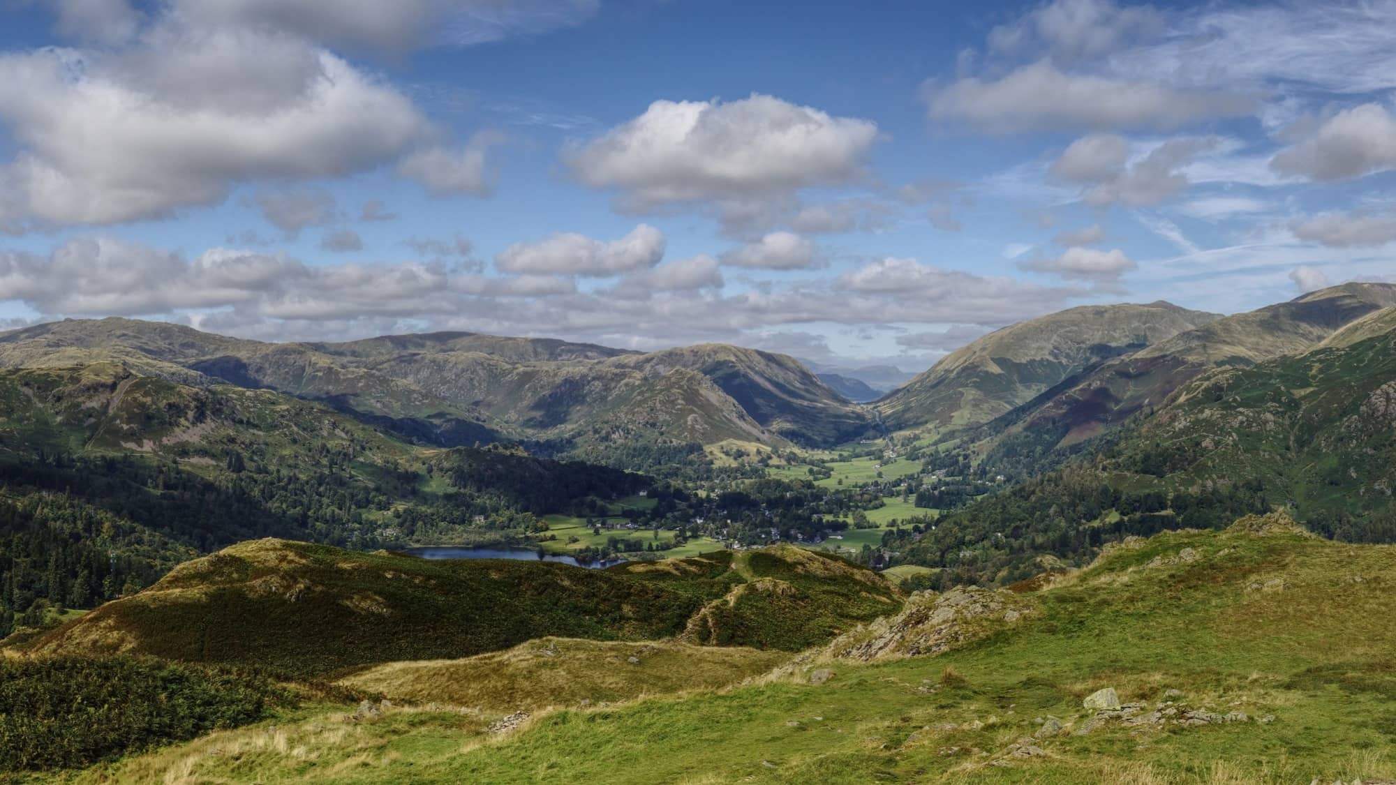
The descent toward Grasmere includes uneven stone steps and short rocky scrambles before reaching Loughrigg Terrace. The Terrace provides a gentler return route with magnificent views over Grasmere and Rydal Water.

The final section follows the lakeside path back toward Rydal. A worthwhile detour is to visit Rydal Cave. A man made cave, which is a relic from slate mining.

The final section follows the lakeside path back toward Rydal.

Highlights of the Loughrigg Fell walk
- Panoramic summit views across Windermere, Grasmere and the central Lake District fells
- The peaceful tarn at Lily Tarn
- Classic Lake District fell terrain
- Easily reached from Rydal Water
Other walks near Rydal Water
This route forms part of a collection of excellent walks around Ambleside and Rydal Water in the central Lake District, ranging from lakeshore paths to short fell climbs with panoramic views.
Loughrigg Terrace walk from Rydal Water – One of the Lake District’s most scenic paths, running high above Rydal Water and Grasmere.
Grasmere circular walk from Rydal — A rewarding circular route via the Coffin Trail to Grasmere, returning along the lakeshore. Offers a mix of woodland paths, open fell views and time in the village.
Rydal Water circular walk – A classic easy route around the lake, with lakeshore paths, woodland sections and views across Rydal Water and towards Windermere.
Parking at Rydal Water (Best Places to Park for Walks)
Several small car parks provide access to the Loughrigg Fell walk around Rydal Water.
White Moss Car Park – approximately 140 spaces located northwest of Rydal Water between Ambleside and Grasmere.
Pelter Bridge Car Park – around 15 spaces located south of Rydal Water near the bridge crossing the River Rothay.
Rydal Lodge (for guests) — Guests staying at Rydal Lodge can avoid parking altogether, with direct access from the garden onto a network of footpaths leading to Rydal Water, Loughrigg Terrace and beyond. It’s an ideal base for exploring the area on foot.
Where to stay near Rydal Water
Many walkers choose to stay between Ambleside and Grasmere to enjoy direct access to routes like Rydal Water, Loughrigg Terrace and the Coffin Trail without needing to drive each day.Staying in this central area allows you to start walks from the door while still being within easy reach of both villages.Rydal Lodge sits in this position beside the River Rothay, with footpaths leading directly to Rydal Water and surrounding fells.
Stay at Rydal LodgeDownload Walk Map PDF